
Dabbling with Google Maps and Google Earth
Here are some pointers to what I've been playing with using Google Maps API and Google Earth [GE] (formally Keyhole)...
Google Earth and Google Maps are registered trademarks of Google Inc. Nearby.org.uk is not affiliated with Google.
In case anybody is
watching this page for updates, you can now subscribe to the
RSS feed or  or even via feedburner.com
-
Maps Nearby Intereactive Map (~17-7-05)
- Uses the Google Maps API to make points from the Location Search viewable on a google map. Uses an AJAX update, which I'm quite pleased with, to fetch markers as you drag the map around. Also pointless Moon version. Thanks to dynamite local for the idea.
- UPDATED: 1-8-05 now adds a link to Google Earth (just under the map), soon this will open similar extents!
-
GE Coordinate Converter (29-7-05)
- includes a link to open the current location in Google Earth, if can be converted to a Lat/Long! (as well as linking to Google Maps and my interactive map above)
-
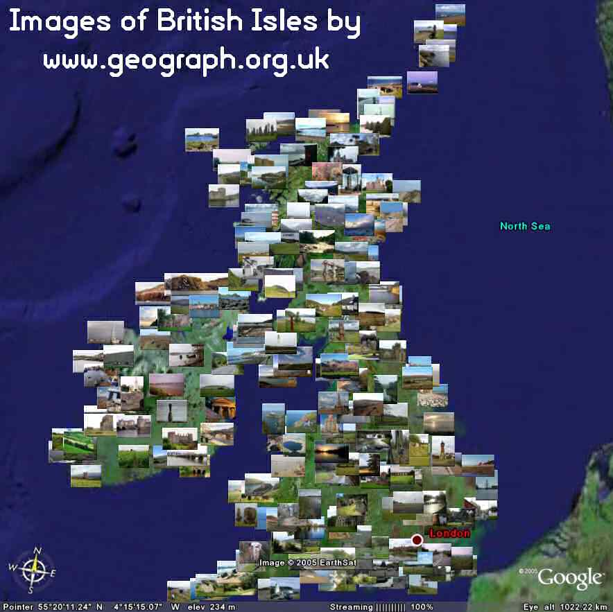
- View latest images and results of searches directly in Google
Earth! Thumbnails of the photos themselves for the marker. See
this page (or
Forum) for more details, now
includes view based refresh. Here is a teaser:
 15
Latest Images Submitted, lots more is possible! Thanks to
geobloggers.com for the
idea.
15
Latest Images Submitted, lots more is possible! Thanks to
geobloggers.com for the
idea.
- View latest images and results of searches directly in Google
Earth! Thumbnails of the photos themselves for the marker. See
this page (or
Forum) for more details, now
includes view based refresh. Here is a teaser:
-
GE Nearby Google Earth NetworkLayers (30-7-05)
- Makes common datasets from the Location
Search available as a Network Link. Simply open , which will add a new folder to your Places window
in Google Earth. Open this up and you can select which layers you want to view.
Dont activate too many at once to avoid killing my server ;-) (See this page
for the FULL list of layers)
- UPDATED: 30-08-05 the layers are now KMZ to save bandwidth, should be a lot faster! The Main link is also a network link so can just refresh it to get new Layers. Delete your current 'Nearby.org.uk NetworkLink' and open this KML file
- See also many more other layers below
- Makes common datasets from the Location
Search available as a Network Link. Simply open
-
GE Nearby Links (31-7-05)
- Open
to get a Network Link that adds a marker in the center of the current view to
open the Coordinate Converter with that location.
(to get links to online maps, location searches and coordinates
etc)
- UPDATED: 01-08-05 now adds a link to Google Maps into the popup. This also tries to open the map to have a similar coverage to that on Google Earth!
- UPDATED: 28-09-05 now places a more accurate center marker thanks to the new <viewFormat> tag, you will need to re-download the kml file!
- Open
-
GE TrigpointingUK -> Google Earth Export (15-8-05)
- Download options include a KML export. Perform a search, choose Download File, and select Google Earth in the dropdown, simple!
-
GE Nearby Postcodes (21-12-05)
- Open
to get a Network Link that adds a marker for each Postcode in the Current View.
Currently works in the UK, US and Germany.
- Open
-
GE View Based Network Link Echo - For Developers (28-12-05)
- Open
to get a simple Network Link that displays a Balloon that just echos back the
BBOX and LOOKAT values, nothing more nothing less.
- Along similar lines is this
which will maintain a circle in the center of the view to give a sence of
scale. The exact size of the circle is configuraable by right clicking on the
the Link and selecting Edit, at the end of the url is the radius of the circle,
all the following values should work: 20kilometers, 2miles, 300meters, 750feet,
2.7km (always use the plural, so 1mile is not valid) [More
Details]
- Open
-
 GE GB & Ireland Grid-Lines
Layer (03-01-06)
GE GB & Ireland Grid-Lines
Layer (03-01-06) - Open to get a Network Link that will
display the OSGB/OSGB36 or Irish Grid '65 on the Google Earth! Very useful for
people who think in Grid References! Gridlines get more detailed as you zoom
in. (Static KMZ Versions Available Too)
- Added: 20-02-21. Created new version that includes sub-KM gridlines. Can now show 0.1km (100m) lines. (just use one or the other, not both)
- Open
-
GE Worldwide UTM Grid-Lines Layer (19-01-06)
- Open for the same again but this time
plotting UTM gridlines, which should work worldwide. I don't know that much
about UTM, so please treat with care!
- Open
-
GE Geograph Hectad's in Google Earth (18-02-06)
- See this page for more information, basically displays the number of photos taken as a 3d bar map.
-
GE KML Placemark Sorter (06-03-06)
- Small utility to take a saved KML of placemarks, and generate a new one with the placemarks sorted into order. Very basic but should be functional. Coded to get round the deficiency in the client where no sorting is available.
-
GE Coverage Bar Graphs for Location Search Layers (17-03-06)
- Along the same lines 'Geograph Hectad's in Google Earth' have created coverage bar graphs for all the layers in the Location Search. Just click the 'Bar' link on this long list of layers. (that page also has links to view the layers normally). See also my post about the specific geocaching/trigs layers at the Groundspeek Forum.
-
GE KML Altitude Filler (09-04-06)
- Have a KML that you would like have a real altitude for every point? For example a elevation profile on gpsvisualiser? Anyway this page will take a KML file, consult a webservice and fill out each altitude point...
-
GE Degrees Compass Echo (09-04-06)
- Similar the the various echo's above (5 and 8) but the name of the placemark is the current heading in degrees
-
GE IARU Locator Echo (06-07-06)
- Open to get a marker in the center of
the current view that is has a name equal to the IARU Locator for the position.
- Open
-
GE Worldwide MGRS Gridlines Layer (06-07-06)
- Open to get MGRS/UTM gridlines. Very similar to the UTM layer above,
but with two differences: 1) the central marker displays a 1m MGRS reference, and 2) grid-lines will
are plotted to 10m resolution (vs 1km). I don't know that much
about MGRS, so please treat with care!
- UPDATED: 25-06-07. See this blog post for explanation of the recent renumbering of the gridlines
- Open
-
GE Coord-Fly-To (06-07-06)
-
GE KML Grouper (15-09-06)
- ... Takes a kml file full of placemarks, and organizes them into a folder tree structure, starting by continent and working down though country to state/county if possible...
-
GE Geograph Superlayer (15-03-07)
- Layer of all Geograph Images, exploiting the new Region functionality of GE4 to only fetch and load detail as you zoom in, in this way the view starts depicting a course overview of the current coverage, zooming in reveals more detail until pictures themselves become visible.
-
GE MGRS Layer for Google Earth - Offline! (19-06-07)
- The MGRS layer above packaged up for use Offline. With instructions for setting up a local webserver.
-
GE FlashEarth in Google Earth (28-08-07)
- (Google Earth 4.2+ on Windows ONLY at the moment) "As you move around the globe a little white arrow follows you around, simply click it to get an approximation of the current view in FlashEarth in a popup balloon." (read more)
-
GE Flight Sim Recorder (01-09-07)
- Heres a little script that records your flight in Google Earth for later review. (Wondering how you fly in Google Earth? See (or) here!!!)
-
GE Blue Marble NG - (Rendered) SuperOverlays (28-10-07)
- Jonathan van Tuijl has taken the time to pre-process the full resolution 500m/pixel imagery into static files, meaning you can view the high resolution imagry very smoothly (I only provide hosting)
-
GE+Maps Export multi-destination route to Google Earth (01-12-07)
- Google Maps includes the ability to create directions taking in many points, however it doesnt offer the ability to directly save these routes. And Google Earth doesn't (yet) offer the ability to do mutli-destination routing. So this page is an attempt to provide the little bit of missing functionality to save routes from Maps, and view them in Earth.
Everything below this point has NOT been updated since mid 2006, sorry about that!
Coming Soon
-
Plot GB and Ireland Gridlines in Google Maps
- Following on from the success of the Google Earth Layer. Alpha preview here of the Map. Very basic due to the projection of Google Maps and rather slow in Firefox due to lack of VML. (will revisit when maps has native SVG support)
-
View search results from TrigpointingUK in Google Maps
- Alpha preview here of the Map.
-
View Levelling Transcriptions Lines on Google Maps and Earth
- Take results where Flush-Brackets have been joined into levelling lines and plot these in google earth... Can use the Polyline in Google Maps, and plottable lines in Google Earth, to make the results more pretty than in the above Intereactive Map.
View-Based Network Layers (21-12-05)
- Nearby.org.uk NetworkLayers - 21 UK POI layers
- Geograph.org.uk - Pictures of British Isles [choose advanced options]
- Flickr.com - Images (via geobloggers.com)
- GEOSnapper.com - Images (more)
- del.icio.us - Pages (via geobloggers.com)
- googleglobe.com - Images & Info
- GeoURL.org - Webpages (powered by GeoURL to Google Earth)
- geocrawler.mapper.ofdoom.com - Webpages (scroll down for instructions)
- dns-loc.mapper.ofdoom.com - Domains/Servers (scroll down for instructions)
- wikipedia.org - Articles (via placeopedia.com)
- yourhistoryhere.com - "Mapping Britains Hidden History".
- Nearby.org.uk Postcode Layers - Shows the nearest postcodes for UK, US and Germany
- Or just open this KML folder containing all of the above
- Geocaching.com - Geocaches [Sign-in required]
Other Notable 'Dables' (within my field of interest!)
- bench-marks.org.uk Interactive
Map
- Plots Levelling Lines on Google Maps
- GeoURL
to Google Earth KML
- Demo of opening a list of URL's from geoURL in Google Earth
- Geocaching.com
-> Google Earth
- Install (Greasemonkey &) this script, to open the currently viewed cache in Google Earth, also links to Get-a-map for the UK! (by Lordelph aka Paul Dixon)
- Geocaching
travel bug Tracker
- Another Greasemonkey Script to track a Travel Bug in Google Earth (again by Lordelph aka Paul Dixon)
Most features on this page (c)2005-2006 Barry Hunter
Google Earth and Google Maps are registered trademarks of Google Inc. Nearby.org.uk is not affiliated with Google.